
(Click on the icon or the chart name to
begin downloading - the file sizes are approximate)
(81k) (Map for terrain file wbngs1.trn)
(141k) (Map for terrain file wbngs1.trn)
B&W map of the WarBirds world showing airfields - altitudes and orientations,
mountain elevations, and target on one 17" x 16" page.
Scaled for use with the MaxOverlays navigational aids.
(This one may prove to be difficult to print.)
![]() New
Guinea Terrain Map (v1.0) (split)
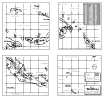
New
Guinea Terrain Map (v1.0) (split)
B&W map of the WarBirds world showing airfields - altitudes and orientations,
mountain elevations, and targets split across four 8.5" x 11" (letter-size)
pages.
(Use this file to print out a map to scale to match the MaxOverlays navigational
aids
if you don't have access to a larger sized printer.)


(56k) (for terrain file wbngs1.trn)
B&W map showing the New Guinea Terrain airfields and targets in detail.
Technical manual size suitable for 3-ring binder. 5 pages

![]() New
Guinea Pronunciation Guide (v1.0)
New
Guinea Pronunciation Guide (v1.0)
(30k)
A guide to pronouncing the places on the New Guinea Map.
If we're not correct at least we're wrong together.
Prints on one 8.5" x 11" (letter-size) page.