
(Click on the icon or the chart name to begin downloading -
the file sizes are approximate)
(65k) (Map for terrain file wbeto2.trn )
(84k) (Map for terrain file wbeto2.trn )
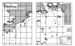
B&W map of the WarBirds world showing airfields - altitudes and
orientations,
mountain elevations, and cities on one 11" x 17"
(tabloid-size) page.
Scaled for use with the WarBirds navigational aids.
![]() ETO
Terrain Map (v3.0) (split)
ETO
Terrain Map (v3.0) (split)
B&W map of the WarBirds world showing airfields - altitudes and
orientations,
mountain elevations, and cities split across two 8.5" x 11"
(letter-size) pages.
(Use this file to print out a map to scale to match the MaxOverlays navigational aids
if you don't have access to a larger sized printer.)
