
(Click on the icon or the chart name to begin downloading -
the file sizes are approximate)
(96k) (Map for terrain file wbawt2.trn )
(131k) (Map for terrain file wbawt2.trn )
(150k) (for terrain file wbawt2.trn )
An HTML chart for determining the course necessary to fly By Fabio Eduardo Fernandes

![]() Arena
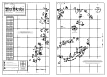
Water Terrain Map (v3.0)
Arena
Water Terrain Map (v3.0)
B&W map of the WarBirds world showing airfields - altitudes and
orientations,
mountain elevations, and cities on one 11" x 17"
(tabloid-size) page.
Scaled for use with the MaxOverlays navigational aids.
![]() Arena Water Terrain Map (v3.0)
(split)
Arena Water Terrain Map (v3.0)
(split)
B&W map of the WarBirds world showing airfields - altitudes and
orientations,
mountain elevations, and cities split across two 8.5" x 11"
(letter-size) pages.
(Use this file to print out a map to scale to match the MaxOverlays navigational aids
if you don't have access to a larger sized printer.)

![]()

![]() Arena Water Airfield Maps (v1.0)
Arena Water Airfield Maps (v1.0)
B&W map showing the Water Arena Terrain airfields and targets in
detail.
The Bomber Version
Shows standardized target bombing runs.
Technical manual size suitable for 3-ring binder. 8 pages

![]() Direction
to Water Arena Airfields Chart (in degrees)
Direction
to Water Arena Airfields Chart (in degrees)
from any airfield in the Water Arena Terrain (wbawt2.trn)
to any other airfield.