Early Maps & Charts
by Bob Heffner
|
Early Maps & Charts by Bob Heffner |
These files are in the PDF format - readable on many computer
platforms and printable by most printers.
A PDF document requires
Adobe's Acrobat Reader in order to be read on screen or
printed.
It is available free from Adobe.
Notes on the maps

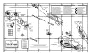
(130k) (Map for terrain file wbawt1.trn)
B&W map of the WarBirds world showing airfields -
orientations,
elevations, HQ's and ports on one 11" x 17" (tabloid-size)
map.

(140k) (Map for terrain file wbawt1.trn)
B&W map of the WarBirds world showing airfields -
orientations,
elevations, HQ's and ports split across two 8.5" x 11"
(letter-size) map.
(Use this file to print out a map to scale to match the navigational
aids below
if you don't have access to a larger sized printer.)


UNDER CONSTRUCTION - This early copy needs to be verified.
E-mail me with any corrections, changes, and addition
suggestions.

(130k) (Map for terrain file wbsea2.trn)
B&W map of the WarBirds world showing airfields -
orientations
and elevations, 88mm ack sites and ranges, HQ's and harbors.

(140k) (Map for terrain file wbsea2.trn)
B&W map of the WarBirds world showing airfields -
orientations,
elevations, HQ's and ports split across two 8.5" x 11"
(letter-size) map.
(Use this file to print out a map to scale to match the navigational
aids below
if you don't have access to a larger sized printer.)

(140k)
B&W maps showing the WarBirds 2.0 Sea Terrain airfields in
detail.
Including an addendum with 88mm ack site and battery
identification system. Technical manual size suitable for 3-ring
binder. 7 pages.

An HTML chart for determining the course necessary to fly
from any airfield in the Water Arena Terrain (wbawt1.trn)
to any other airfield.
By Fábio Eduardo Fernandes
(80k) (Map v1 for terrain file wbsol4.dat)
A B&W map showing all the islands on one 8.5" x 14"
(legal-size) map
with place names and pronunciation guide.

(86k) (Map v1 for terrain file wbpac3.dat)
A B&W map showing all the islands on one 8.5" x 11"
(letter-size) map.

(60k) (Map v1 for terrain file wbmed1.dat)
A B&W map showing the Mediterranean Terrain on one 8.5" x 11"
(letter-size) map.
(60k) (Map v1 for terrain file wbmed1.dat)
A B&W map showing the Mediterranean Terrain on one 11" x 17"
(tabloid-size) map.
Included are 'historical' place names.

(86k) (Map v1 for terrain file wbeto2.dat)
A B&W map showing the European Theater Terrain on one 8.5" x
11" (letter-size) map.
(86k) (Map v1 for terrain file wbeto2.dat)
A B&W map showing the European Theater Terrain on one 11" x
17" (tabloid-size) map.
Included are 'historical' place names.


Solomon Islands - Airfield Maps v2.0
(150k)
B&W maps showing the Solomon Islands airfields in detail.
Technical manual size suitable for 3-ring binder. 9 pages.
Pacific Islands - Airfield Maps v2.0
(140k)
B&W maps showing the PAC airfields and targets in detail.
Technical manual size suitable for 3-ring binder. 7 pages.
Mediterranean Terrain - Airfeld Maps
v2.0 (140k)
B&W map showing the Mediterranean Terrain airfields and targets
in detail.
Technical manual size suitable for 3-ring binder. 7 pages.
European Theater - Airfeld Maps v2.0
(192k)
B&W maps showing the European Theater airfields and targets in
detail.
Technical manual size suitable for 3-ring binder. 13 pages.
|
|
|
|
If you'd like to link to this page go right ahead. Just let me
know so I can check out your pages, too.
If you want a graphic use this one: ![]()
![]()
I'd appreciate it if you could work in the 'capital theta' in MaxØverlays. Copy and paste the line below.
![]()
![]()
![]()
![]()
![]()
